Today's date is: September 19, 2026
The specifics of the geographic boundaries promised to Abram
The geographic boundaries promised to Abram in Genesis 15:18–21 represent the broadest and most expansive definition of the Promised Land found anywhere in the Hebrew Bible. Unlike later, narrower descriptions meant for tribal settlement—which generally restricted the land to Canaan proper (west of the Jordan River)—the Genesis 15 blueprint outlines a vast geopolitical corridor spanning the heart of the ancient Middle East.
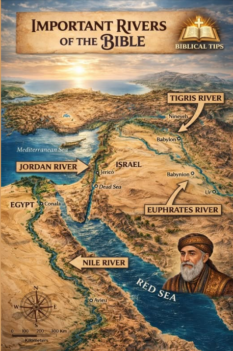
🚧1. The Macro-Boundaries (The Two Rivers)
In verse 18, God establishes the borders using two massive aquatic landmarks:
- The Western/Southern Boundary ("The River of Egypt"):
- The Debate:
Bible scholars and geographers heavily debate this location. Some interpret Nahar Mitzrayim (River of Egypt) as the eastern branch of the Nile River delta.
- The Consensus:
Most historical commentators and archeologists identify it as the Wadi El-Arish. This is a massive seasonal torrent bed in the northeastern Sinai Peninsula that empties into the Mediterranean Sea about 50 miles south of Gaza, acting as the traditional natural border between the Egyptian empire and Canaan.
- The Eastern/Northern Boundary ("The Great River, the Euphrates"):
- This boundary is unambiguous. The Euphrates River flows from southeastern Turkey down through modern-day Syria and Iraq. Delineating this as the border places the edge of the territory deep into Mesopotamia, the birthplace of Abram himself.
🌏2. Modern Geopolitical Equivalence
If mapped onto a modern atlas, the territory encompassed by the Genesis 15 covenant is significantly larger than the borders of the modern State of Israel. It encompasses:
- All of modern Israel and the Palestinian Territories.
- All of modern Lebanon.
- The vast majority of modern Syria.
- All of modern Jordan.
- Substantial western portions of Iraq (up to the banks of the Euphrates).
- The Sinai Peninsula (part of modern Egypt) and northwestern edges of Saudi Arabia.
🚧3. Micro-Boundaries: The Ten Nations (Verses 19–21)
Rather than providing a standard point-to-point physical compass tracking (as seen later in Numbers 34), Genesis 15 defines the internal landscape by listing ten specific ethnic groups occupying the territory at the time:
- The Nomadic/Desert Tribes:
The Kenites, Kenizzites, and Kadmonites. These groups primarily lived in the arid regions of the Negev desert and east of the Jordan River (areas later associated with Edom, Moab, and Ammon)
- The Imperial Outposts:
The Hittites. An Anatolian superpower whose territory and cultural influence extended south into northern Syria and Canaan during the patriarchal era.
- The Agrarian & Local Tribes:
The Perizzites, Girgashites, and Canaanites. These were the core agricultural and urban populations scattered throughout the valleys and coastlines of the Levant.
- The Giants:
The Rephaites. A group culturally remembered in the biblical narrative for their imposing physical stature, primarily living in the northern Transjordan region (Bashan/Golan Heights).
- The Highland Strongholds:
The Amorites and Jebusites. Mountain-dwelling groups; the Amorites controlled vast swaths of hill country, while the Jebusites maintained the fortified hill city that would eventually become Jerusalem.
📜4. Historical Context & Fulfillment
From a narrative standpoint, Israel only briefly approached these maximum conceptual borders. During the golden age of the United Monarchy under King David and King Solomon, Israel’s sphere of sovereign control, vassal states, and tribute-paying kingdoms extended from the border of Egypt all the way north and east to the Euphrates River (as noted in 1 Kings 4:21).